Friday, October 2, 2009

CHITRADURGA


                           PLACE OF MADAKARI

Chitradurga district is an administrative district of Karnataka state in southern India. The city of Chitradurga is the district headquarters. Chitradurga gets its name from Chitrakaldurga, an umbrella-shaped lofty hill found there. Tradition dates Chitradurga District to the period of the Ramayana and Mahabharata. The whole district lies in the valley of the Vedavati River, with the Tungabhadra River flowing in the northwest. During the British times it was named Chitaldrug. The district was practically ruled by all the well known dynasties that ruled Karnataka.
The district is hilly, with lots of forts and villages. The district is bounded by Tumkur District to the southeast and south, Chikmagalur District to the southwest, Davanagere District to the west, Bellary District to the north, and Anantapur District of Andhra Pradesh state to the east. Davanagere District was formerly part of Chitradurga. The district is divided into taluks, namely Chitradurga, Hiriyur, Hosadurga, Holalkere, Challakere and Molakalmuru. It is rich in mineral deposits, including gold prospecting at Halekal, Kotemardi or Bedimaradi, etc., and open cast copper mines at Ingaldhal.
Chitradurga is a city located in the Indian state of Karnataka. Chitradurga gets its name from Chitrakaldurga, an umbrella-shaped lofty hill found here. Tradition dates the Chitradurga district to the period of the Ramayana and Mahabharatha. The whole district lies in the valley of the Vedavati river, with the Tungabhadra flowing in the NorthWest. The Well Known Tourist Place in Chitradurga is the Fort. The Fort of Chitradurga with seven circumambulations surrounds the seven hills of Chinmuladri range. Actually the Construction of this fort started during 10th Century A.D and completed in 18th Century A.D during the rule of palegars. According to an estimate the total length of the fort is about 8 Kms. As per Chitradurga District Gazetteer this fort as 19 Gateways, 28 Postern Gates, 35 Secret Entrances, 4 invisible Entrances, 50 Warehouses, apart from other monuments.
Chitradurga, on the highway linking Bangalore with Hospet, is famed for its massive Kallina Kote (Palace of Stone) fort, a marvel of military architecture made impregnable by the Nayak Palegars. Visitors to Chitradurga’s Kallina Kote cannot help but be astounded by the sheer size of everything within the Fort. Encircled by seven massive walls, each with its independent gate, the fort has 19 gateways, 38 posterior entrances, four of which are secret, granaries, oil pits, water tanks, a palace and a mosque. As if that was not enough, the approach to each gate is uphill and through passages that twist and turn, thus making it impossible to use elephants or battering rams to break down the gates. Additionally every wall has pigeonholes from where soldiers could rain down arrows on invaders.


PLACES IN CHITRADURGA

Chitradurga Kote: is only of its kind of fort. As it is built on top of Hill with Stones. Chitra-durg gets names because of this fort. Chitra durga meaning Picture Perfect Fort

Ashoka Siddapura: is an important archeological site where emperor Ashoka's edits were found. Nearby is Ramagiri, a hillock that has mythical associations with the epic Ramayana. A temple dedicated to Rameshwara built in 926 CE. exists here.

Brahmagiri village: is the ancient site of Ishila, one of emperor Ashoka's provincial capitals. His earliest rock edicts in Brahmi script and Prakrit language (3rd c. BC) containing Kannada words were discovered here.

Chandravalli: is an ancient archeological site where painted pottery and coins from the Shatavahana empire and prehistoric times were discovered. The rock inscription of king Mayurasharma dated 450CE. discovered here gave historians much information about Karnataka's first Kannada kingdom.

Hiriyur: situated on the right bank of Vedavathi river is famous for its Tirumalleshawara temple. The temple has impressive lofty gopura and the ceiling of the main hall is painted with scenes from the Shivapurana and Ramayana.

Neerthadi: is famous for its Ranganathaswamy temple built in Vijayanagar style.


Vani Vilas Sagar:(also known as Mari Kanive)an artificial lake built by the Mysore Maharaja across the river Vedavathi. The reservoir has two mantapas built in saracenic style.

Thamatekallu: has ancient rock inscription and the oldest virgallu or hero stone inscription in Karnataka.

Holalkere: is well known for its 10th century Jain settlement and 9 ft. tall statue of Bala Ganapathi, a child form of Hindu god Ganapathi.

Doddahottrangappa Hill: has a Ranganathaswamy temple on top of a hillock which is a trekkers paradise.

Halu Rameshwara: near Hosadurga is well known for the temple & wells, the well has wihte coloured water (looks like milk) in it that's why the name 'Halu' Rameshwara.

HOSADURGA: A PLACE ALMOST COVERED BY HILL SURROUNDED.

ನನ್ನ ಚಿಕ್ಕಮಗಳೂರು


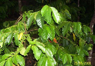
Chikkamagaluru is a district in the Indian state of Karnataka. Chikkamagaluru is where coffee was first cultivated in India. This district is a tourist's paradise with various hill stations, waterfalls and religious sites present here. The mountains here which are a part of the Western Ghats are also the source of rivers like Tunga and Bhadra. In Chickmagalur district, the major commercial crop is coffee. Other commercial crops are Pepper, Cashew nuts etc.. mullain giri, the highest peak in Karnataka (viz., 6,317 feet high from Sea Level) is 12 Kms away from Chickmagalur. Number of rivers originates from the hills of Chickmagalur district and flow in all the seasons. Rivers such as, Bhadra, Tunga, Hemavathi, Netravathi & Vedavathi. Several minerals are found in the district such as iron, magnetite, granite etc., major iron ore company in Asia is located at Kudremukha in Mudigere taluk of Chickmagalur district.

Chickmagalur district was called Kadur district till 1947. It is situated roughly in the south-western part of Karnataka state. A large area of this district is 'malnad', i.e., a largely forested hilly region of heavy rainfall. The district takes its name from the headquarters town of Chickmagalur which literally means younger daughter's town - Chikka+Magala+Ooru-(in Kannada). It is said to have been given as a dowry to the younger daughter of Rukmangada, the legendary chief of Sakrepatna. Another part of the town bestowed on the elder daughter is known as Hiremagalur.
The district is situated between 12° 54´ 42´´ and 13° 53´ 53´´ north latitude and between 75° 04´ 46´´ and 76° 21´ 50´´ east longitude. Its greatest length from east to west is about 138.4 kilometers and from north to south 88.5 kilometers. General boundaries are
East - Tumkur district ,South - Hassan district, West - Western Ghats which separates it from Dakhina Kannada (South Kanara), North - East : Chitradurga district, North - Shimoga district.

Places of Interest


Kemmangundi: 55 km north from Chikkamagaluru town is Kemmangundi, a scenic hill

station on the Baba Budan Giri range of hills. Kemmangundi is also known as K.R. Hills after the Wodeyar King, Krishnaraja Wodeyar, who had made it his favourite summer camp. Kemmangundi, at a height of 1,434 meters, is surrounded by thick forests and a salubrious climate through out the year. It is surrounded by the Baba Budan Giri range and blessed with silver cascades of mountain streams and lush vegetation.
Kudremukh and Kudremukh National Park: 95 km southwest of Chikkamagaluru town is Kudremukh range (in Kannada Kudure = horse and mukha = face), so named because of the unique shape of the Kudremukh peak. Overlooking the Arabian sea, the broad hills are chained to one another with deep valley & steep precipices. Situated at 1,894.3 meters above sea level, Kudremukh is rich in iron ore


Mullayanagiri: Mullayanagiri is part of the Baba Budan Giri Hill Ranges here. It stands 1930 meters tall and is the tallest peak in Karnataka. Its height is famous mostly for watching sunsets from. It is 16 km from Chikkamagaluru town. Driving to Mullayanagiri is worth taking a risk. On the way is Sitalayanagiri where the water in the Shiva temple neither increases nor decreases. The road to Mullayanagiri is very narrow with a views from steep cliffs.
Datta peeta (Baba Budan Giri): To the north of Chikkamagaluru town is the Baba Budan Giri Range or Chandra Drona Parvatha as it was known in the ancient times, which has one of the highest mountain peaks between the Himalayas and the Nilgiris. The peak takes its name from the Muslim saint, Baba Budan, who resided here more than 150 years ago.
Manikyadhara Falls: is a waterfall near the famous pilgrim centre Baba Budan Giri Dattatreya Peetha where water spills down like small pearls giving the visitors a memorable shower bath.
Kallathigiri Falls: Just 10 km away from Kemmangundi is Kallahathigiri falls, also known as Kalahasti falls. Water cascades down from the top of the Chandra Drona hill from a height of 122 meters amidst fascinating scenery. There is an old Veerabhadra temple dedicated to Lord Shiva, constructed in a gap between rocks. This temple can be approached after crossing the waterfall.
Hebbe Falls: This beautiful waterfall is over 10 km away from the famous hill station, Kemmangundi. Here water streams down from a height of 168 meters in two stages to form Dodda Hebbe (Big Falls) and Chikka Hebbe (Small Falls).
Shanti Falls: This is a beautiful waterfall on the way to Z-Point in Kemmangundi.
Hanumana Gundi Falls: Located 32 Km. from the Kalasa, the waterfall has water falling on to Natural rock formations from a height of more than 100 feet.
Kadambi Falls: This is a waterfall located in the Kudremukh National Park.
Sringeri: 90 km west of Chikkamagaluru town is Sringeri situated on the banks of Tunga, a Vedic Peetha established by Sri Adi Shankara, the exponent of the Advaita philosophy in 9th Century A.D. It is famous for Vidyashankara Temple originally constructed by the Hoysalas and later completed by the founders of the Vijayanagar Empire and Sharada temple, an early 20th. century addition. In the Vidya Shankara shrine, there are 12 zodiac pillars, which are so constructed that the rays of the sun fall on the pillar corresponding to the month. Horanadu: Horanadu is 100 km southwest of Chikkamagaluru and has an ancient Annapoorneshwari Temple, which has been renovated recently. With the installation of the new image of Adi Shakti, now the temple is called Adi-Shaktyatmaka Shri Annapoorneshwari. The place attracts lots of pilgrims who are provided free boarding and lodging by the temple.
Vidyasankara temple in Shringeri: Mahadwara (main door) of Annapoorneshwari temple in HoranaduKalasa: Kalasa is 92 km southwest of Chikkamagaluru and situated on the banks of the river Bhadra. It is surrounded by lofty hills of the Western Ghats and is looked upon as one of the pancha-kshetras on the banks of the Bhadra. Close by are the pancha theerthas, the five sacred ponds. On a small hillock here is the Kalaseshwara temple in dedicated to Ishwara, with a Kshetrapala shrine of soap stone in Hoysala style nearby. The Madhawacharya bande, a large boulder at one of the theerthas here, is supposed to have been placed by Shri Madhawacharya the founder of the Dvaita school of philosophy. A statue of this acharya is carved on the upper portion of the rock. Guru Dattatreya Bababudanswamy Darga: Situated on the Baba Budan Giri is the Inam Dattatreya Peetha venerated by the Hindus and the Muslims alike. A laterite cave here is believed to have been sanctified by the residence of Dattatreya Swami as well as Hazrat Dada Hayat Mir Khalander. The worship here is conducted by a fakir and the annual jatra or urs is attended by both Hindus and Muslims with great fervors. Amritapura: 67 km north of Chikkamagaluru, Amrithapura is known for the Amritheshwara temple built in 1196 A.D by Amriteshwara Dandanayaka, a general of the Hoysala ruler Veera Ballala II. Delicacy of touch, originality of design and fine features have made this temple one of the notable structures of the Hoysala period. Belavadi: Located 29 kms southeast of Chikkamagaluru town on the Chikkamagaluru-Javagal road and 10 kms north west of Halebidu, Belavadi is famous for Ornate temple of Veeranarayana. Belavadi is also famous for the temple of 'Udbhava Ganapathi'.
River Tern Nestling: in Bhadra Wildlife SanctuaryBhadra Wildlife Sanctuary: Occupying 495 km². of wildlife sanctuary and Project tiger reserve, this region is an important watershed of the Tungabhadra river. The huge reservoir here is the main water supply to several districts in the rain shadow regions of south Karnataka. The forests here are rich in Bamboo and birds species unique to both the Malabar and Sahyadri ranges.
Kudremukh National Park: The Kudremukh National Park (latitudinal range 13°01'00" to 13°29'17" N, longitudinal range 75°00'55' to 75°25'00" E) is the largest declared Wildlife Protected Area (600 km²) of a tropical wet evergreen type of forest in the Western Ghats. The Western Ghats is one of the twenty-five hot spots identified for bio-diversity conservation in the world. Kudremukh National Park comes under the Global Tiger Conservation Priority-I, under the format developed jointly by Wildlife Conservation Society (WCS) and World Wide Fund-USA.


Thursday, October 1, 2009